
Hello! Let's dive into the next chapter of Bogotá's story.
In our last lesson, we witnessed the trauma of the 'Bogotazo.' We saw how the assassination of Jorge Eliécer Gaitán in 1948 didn't just reduce downtown to rubble; it violently redrew the city's map. The event triggered two crucial developments: the flight of the economic elite from the city center to the north, and a massive wave of migration from the countryside as the civil war known as La Violencia erupted. These forces set the stage for an era of explosive, chaotic urban growth.
Today, we will examine the consequences of that explosion. Our goal is to analyze the visual consequences of rapid 20th-century urbanization, linking population growth to contemporary challenges like spatial inequality. We'll explore how the city swelled in size, how an official system was designed to manage this growth, and how that very system ended up carving inequality into the streets and buildings of Bogotá. From a design perspective, this is a fascinating and cautionary tale of how a system's unintended consequences can define the user experience of a city for millions.
The Great Migration and the Unplanned City
The Bogotazo was the urban epicenter of an earthquake whose tremors were felt across the nation. The ensuing decade of conflict, La Violencia, was a brutal war between the Liberal and Conservative parties that ravaged rural Colombia. For countless families caught in the crossfire, the only option was to flee. The cities of the "golden triangle"—Bogotá, Medellín, and Cali—became beacons of relative safety and opportunity.
This migration was immense. To understand the drivers and scale of this growth, let's turn to the article "Spatializing Stratification: Bogotá."
Spatializing Stratification: Bogotá
This article by Rob Shields provides the historical context for Bogotá's 20th-century population boom, connecting industrialization and rural violence to the city's urbanization.
Please read the introduction, from the beginning down to the end of paragraph 7 (ending with '...25.6% in 1985'). Focus on how the combination of industrialization and armed conflict funneled population growth into the big cities, transforming them into primary destinations for displaced people.
As the reading highlights, Bogotá's population skyrocketed. Between 1938 and 1985, the share of Colombia's population living in the three main cities nearly quadrupled. This wasn't a planned, orderly expansion. It was a desperate flood. Newcomers built their own homes on the city's periphery, often on undeveloped, undesirable land on the steep hillsides to the south and east. This created a sprawling landscape of what the article calls "self-constructed neighborhoods" or informal barrios.
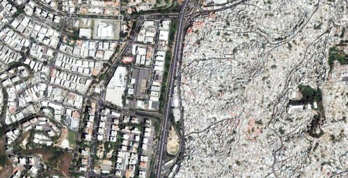
This rapid, informal growth created a major challenge for the city government: how to provide basic public services like water, electricity, and sanitation to a rapidly expanding and unequal city? Their solution was a unique and powerful system that would reshape the city's identity.
Designing Inequality: The 'Estratos' System
In the 1990s, the Colombian government implemented a nationwide policy of socio-economic stratification, or estratos. From a systems design perspective, the logic was straightforward: create a tiered system to charge for public utilities, where the wealthiest subsidize the poorest.
The city was divided into six strata, or layers:
- Estratos 1 (Bajo-Bajo) & 2 (Bajo): The lowest strata, receiving the largest subsidies on their utility bills.
- Estrato 3 (Medio-Bajo) & 4 (Medio): The middle strata, who pay approximately the real cost of their services.
- Estratos 5 (Medio-Alto) & 6 (Alto): The highest strata, who pay a surcharge on their bills to fund the subsidies for strata 1 and 2.
The crucial design choice was that a dwelling's stratum isn't based on the owner's income, but on the physical characteristics of the house and its immediate environment—the quality of the facade, the materials used, the state of the street, and the presence of amenities like parks.
This system, intended to create economic equity, had a powerful and unintended side effect: it formalized, visualized, and deepened social and spatial segregation. It created a powerful mental map for every inhabitant, where your estrato became a shorthand for your social class, your opportunities, and your place in the city.
The following resource explains how this system works and its profound impact on the urban landscape.
Spatializing Stratification: Bogotá
These sections from 'Spatializing Stratification: Bogotá' detail the logic of the 'estratos' system and how it has produced a segregated city.
Please read Section 2, 'Urban Space and Social Hierarchy in Colombia,' and Section 3, 'Tangible and Intangible Stratifications in Bogotá.' As you read, focus on how a system designed for utility billing became a tool for socio-spatial segregation, influencing everything from real estate values to social stereotypes (like gomelos vs. ñeros). Pay special attention to Figure 2, the map showing the distribution of strata across the city.
The map in the reading (Figure 2) is a stark visualization of this inequality. You can clearly see the concentration of high strata (5 and 6) in the north (Usaquén, Chapinero) and the vast areas of low strata (1 and 2) in the south (Ciudad Bolívar, Usme, Bosa). The system didn't just describe the city's inequality; it locked it in place, making it tangible and visible on a block-by-block basis.
Test your understanding!
From a product design or systems thinking perspective, what is the fundamental flaw in the estratos system's design? Why did a system intended to promote equity end up reinforcing inequality?
Show answer
The fundamental flaw lies in using the physical characteristics of a home and neighborhood as a proxy for the inhabitants' income. This creates a powerful negative feedback loop:
- A neighborhood is classified as low stratum due to poor housing quality.
- Because it's low stratum, it becomes less attractive for investment, and property values stay low.
- Public and private services may be of lower quality. It becomes stigmatized.
- People with more resources move out, and only those with fewer resources can afford to move in.
- The neighborhood's physical characteristics don't improve (or they decline), reinforcing its low-stratum status.
The system ends up trapping entire areas in a cycle of disinvestment and stigmatization. It penalizes physical improvements (which could raise the stratum and thus the bills) and codifies geography as destiny. It's a classic case of a system optimizing for one metric (utility payment equity) while having disastrous unintended consequences on the broader social fabric.
The Lived Consequence: Rappitenderos and the Battle for Public Space
This history of migration and stratification isn't just an academic exercise; it plays out every day on the streets of Bogotá. A perfect contemporary example is the tension surrounding delivery workers, particularly for the app Rappi.
This conflict is a direct visual and social consequence of the city's unequal design. The demand for services like Rappi is highest in the affluent, high-strata neighborhoods of the north. The workers who provide these services—the rappitenderos—are often from low-strata neighborhoods, or are recent migrants, for whom this is one of the few available jobs.
When these workers wait for orders in the parks and on the sidewalks of high-strata areas, it creates a clash. The residents, who see public space as a place for leisure, perceive the workers as an "invasion." This situation brilliantly illustrates how the city's segregated design creates friction when its separated worlds are forced to interact.
Delivery Workers Expose the Troubling Ideology of Public ...
The article 'Delivery Workers Expose the Troubling Ideology of Public Space in Bogota' provides a powerful, present-day case study of the spatial inequality we've been discussing.
Please read from the beginning of the article down to the end of the section that discusses Enrique Peñalosa's vision for public space. Focus on how the socio-spatial segregation enabled by the 'estratos' policy makes the 'rappitenderos' seem 'out of place' in the very neighborhoods they service.
This case study is a microcosm of the larger urban story. The rappitendero waiting on a sidewalk in a wealthy neighborhood is the physical embodiment of the city's economic dependencies and social divisions. Their presence disrupts an idealized "user experience" of public space that was designed with leisure, not labor, in mind, making visible the invisible workforce that makes the high-strata lifestyle possible.
Conclusion
Today we've traced the arc of Bogotá's explosive 20th-century growth and the resulting inequality.
- A City Shaped by Migration: We saw how rural violence (La Violencia) triggered a massive, unplanned migration to Bogotá, leading to the proliferation of informal settlements and a sprawling urban form.
- The Design of Inequality: We analyzed the
estratossystem—a policy designed for one purpose (managing utility costs) that had the unintended consequence of codifying and deepening socio-spatial segregation, creating a visually and socially divided city. - A Legacy of Friction: We examined how this historical inequality manifests today in conflicts over public space, where different "users" of the city—like affluent residents and precarious delivery workers—clash because the city's design has placed them in separate and unequal worlds.
The story of 20th-century Bogotá is a powerful lesson in urban design: a city is more than its buildings and streets. It is a complex system where policy, history, and human behavior intersect, often with profound and lasting consequences.
In our next lesson, we'll shift our focus to the 21st century. We will critique the urban design and user experience of major projects like the TransMilenio bus system and public space renewals, asking whether these modern interventions have successfully addressed, or perhaps even exacerbated, the deep-seated challenges of inequality we've discussed today.
Can't find a good explanation? Sign up and we'll make it for you
Sign up