
Hello. Last lesson established the scale rule: a landscape is the whole area you can see, while a landform is one natural physical feature within that area. Now the focus is on recognition. By the end of this lesson, you should be able to look at a photograph or a simple physical map and accurately name common features such as mountains, valleys, plains, plateaus, rivers, lakes, bays, and peninsulas.
For tomorrow’s test, do not try to memorise long explanations of how every landform formed yet. First, train yourself to notice each landform’s shape, height, and relationship to water or nearby land.
Build a visual vocabulary
A landform is a natural feature of Earth’s surface. It may be high, low, flat, steep, dry, or beside water. The important thing is that it is a recognisable part of the terrain.
Read the opening of National Geographic Education’s “Landform” page to fix the core definition and see which features are commonly grouped as landforms.
Under “Instructional Links,” read the opening two sentences, from the definition and examples. Focus on the fact that mountains, hills, plateaus, and plains are major landforms, while valleys and canyons are other important examples.
A map or test question may also include rivers, lakes, bays, and islands alongside landforms. Strictly speaking, a river and lake are bodies of water rather than shapes of land, but in Grade 8 map questions they are usually treated together as natural physical features. Identify them precisely rather than worrying about the category label.
Use this recognition guide.
| Feature | What to look for in a photograph | Key idea |
|---|---|---|
| Mountain | Very high land with steep slopes and a peak or ridge | Higher and usually steeper than nearby land |
| Hill | Raised, rounded land with gentler slopes | Like a smaller, lower mountain |
| Plain | Large area of mostly flat or gently rolling land | Flat and usually low compared with nearby land |
| Plateau | Broad, flat land that is clearly higher than surrounding land | A high flat top, often with steep edges |
| Valley | Low area between hills or mountains, often containing a river | Land slopes down into it from both sides |
| Canyon | Deep, narrow valley with very steep rock sides | A much steeper, rockier valley |
| River | Long, narrow, flowing channel of water | It travels across land toward another body of water |
| Lake | Water completely surrounded by land | Enclosed water |
| Bay | Part of the sea partly enclosed by land | Water curves into the land |
| Peninsula | Land surrounded by water on three sides | Land sticks out into water but remains joined to mainland |
| Island | Land completely surrounded by water | Detached from the mainland by water |
| Coastal plain | Flat, low land next to the sea | A plain beside a coast |
Watch this short section for a clear visual comparison of the four landforms most likely to appear in a basic identification question.
Types of Landforms | Learn about many different natural features of the earth
Watch “Types of Landforms” from Learn Bright for its quick visual definitions of mountains, valleys, plains, and plateaus.
Watch mountains, then valleys, plains, and plateaus. As you watch, focus on the visual contrast: mountain versus hill-like high ground; plain versus plateau; and valley as a low space between higher areas.
The two comparisons that matter most
Students often confuse a plain and a plateau because both can be flat.
- A plain is broad and flat, usually at a relatively low elevation.
- A plateau is broad and flat but raised above the surrounding land.
A plateau can look like a table: a flat top with a noticeable drop or steep slope around part of its edge.
Students also sometimes confuse a mountain and a hill. There is no single worldwide height that separates them, so use the visual evidence:
- A mountain usually has greater height, steep slopes, and a clear peak or ridge.
- A hill is lower and often more rounded.
If a photograph makes the difference unclear, avoid inventing a measurement. Describe what you can see: “a steep, high mountain” or “a low, rounded hill.”
Read photographs by shape and position
The Common Natural Landforms diagram puts several features into one landscape. Use it as a visual reference rather than trying to memorise every label in one go.
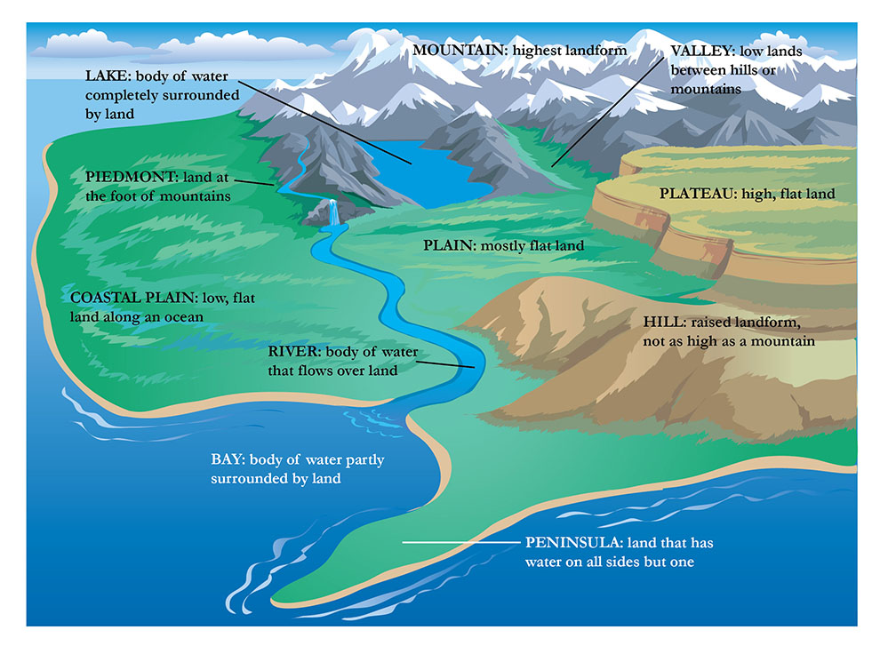
Notice the clues built into the scene:
- The mountains have the greatest elevation and steep, jagged sides.
- The valley is low land between the mountains. A river runs through it.
- The plateau on the right is high and flat, with steep sides around its edge.
- The plain is flatter, more open land below the plateau and mountains.
- The river is narrow and connected; it flows from inland toward the sea.
- The lake is surrounded by land.
- The bay is sea water that curves into the coast and is partly enclosed by land.
- The peninsula projects into the sea. It has water on three sides but is still attached to the larger land area.
- The coastal plain is low, flat land beside an ocean.
A dependable photograph routine
When you see an unfamiliar photograph, scan it in this order:
-
Look for the highest land.
Peaks, steep slopes, and ridges suggest mountains. Lower rounded rises suggest hills. -
Look for flat surfaces.
Decide whether the flat area is low, which suggests a plain, or raised above nearby land, which suggests a plateau. -
Look for low spaces between high areas.
A long low area between hills or mountains is a valley. If it is very deep, narrow, and steep-sided, it may be a canyon. -
Trace the water.
Is it enclosed by land, flowing across land, or part of the sea entering the coast? This separates a lake, river, and bay. -
Check how land meets water.
Land sticking out into water is a peninsula; land completely cut off by water is an island.
Do not name a feature just because it is close to another one. A river can run through a valley, but the river is not the valley. A lake may lie between mountains, but the lake is not a mountain landform.
Coastal features: name them now, explain them later
Coastal questions often show a mixture of land and sea. For identification, these are useful terms:
- Cliff: a steep rock face, often beside the sea.
- Beach: an area of sand or pebbles along a shore.
- Headland: a piece of resistant land that sticks out into the sea.
- Bay: an inward curve of the sea partly sheltered by land.
- Peninsula: land nearly surrounded by water, but still connected to the mainland.
You will learn the processes that create cliffs, arches, stacks, and wave-cut platforms in the next module. For now, a correct name is enough.
Translate a map into a real landscape
A photograph shows the land from the side or above. A map represents it from above, using symbols, colours, labels, and sometimes contour lines. The first rule is simple:
Read the map key before you identify features.
Colours can be helpful, but keys are more reliable. Many simple physical maps use blue for water and green or brown for land, but every mapmaker may choose slightly different colours and symbols.
Map Skills 3: Landforms With Map Key - Learn How to Read Maps
Watch selected parts of “Map Skills 3: Landforms With Map Key” from Miacademy & MiaPrep Learning Channel to practise using a map key to recognise basic physical features.
Begin with the landform map for the idea of a map showing terrain. Then watch water and mountains to compare lake, island, and mountain symbols. Finish with rivers and keys. Focus on the idea that a map symbol only has a precise meaning when you check its legend or key.
Recognising features on a simple map
On a basic map without contour lines:
- A river is usually a thin blue line. It may curve, join another river, or lead into a lake or sea.
- A lake is usually a blue enclosed shape.
- An island is a land-coloured shape completely inside a larger blue water area.
- A peninsula is land protruding into blue water while remaining connected to the mainland.
- A mountain may be shown by small triangular peaks, shaded high ground, or a labelled mountain symbol.
- A plain may appear as a wide, mostly unbroken lowland area.
- A forest is often shown by repeated tree symbols. It is a natural feature of the landscape, but it is not itself a landform.
Contour lines: seeing height on a flat map
A contour line joins places that are at the same height above sea level. A contour map is therefore a way of showing three-dimensional land on flat paper.
Read contour maps using these rules:
| Contour pattern | What it tells you |
|---|---|
| Contour lines close together | The slope is steep because height changes quickly over a short distance. |
| Contour lines far apart | The slope is gentle because height changes slowly over a longer distance. |
| Closed loops with heights increasing toward the centre | A hill or mountain summit. |
| Broad high area with relatively level contours on top and steep contours around edges | A plateau. |
| Contours bending into a V shape across a river | A valley; the point of the V faces uphill, or upstream. |
In the Contour Map and Cross-Section image, the land rises from to , , and . The nested shapes on the map represent higher ground toward their centres. The larger raised area on the left is the highest hill; the smaller raised area on the right is a lower hill.
Always check the contour interval, the difference in height between neighbouring contour lines. A map might use metres, metres, or another value. Do not assume the interval without looking at the labelled lines or key.
Test-ready identification language
For an “identify” question, your answer can usually be short:
- “This is a plateau.”
- “The blue enclosed area is a lake.”
- “The steep-sided low area between mountains is a valley.”
- “The land projecting into the sea is a peninsula.”
If the question asks you to use evidence, add one visible clue:
This is a plateau because it has a broad, flat surface raised above the surrounding land.
This is a valley because it is low land between higher mountain slopes, with a river running through it.
This is a lake because the water is completely surrounded by land.
Avoid these common mistakes:
- Calling any flat land a plain without checking whether it is raised. It could be a plateau.
- Calling a bay a lake. A bay connects openly to the sea; a lake is enclosed by land.
- Calling a peninsula an island. A peninsula remains attached to the mainland.
- Calling the entire image “a mountain” when it contains several features. The whole image may be a mountainous landscape containing mountains, valleys, and rivers.
- Using “hill” and “mountain” as exact opposites based only on one imagined height number. Use the relative steepness and height shown.
A quick final scan before answering is useful: identify the high land, low land, flat land, and water first. Most common landforms become much easier to name once you sort the scene in those four ways.
You can now identify the main natural features likely to appear in a Grade 8 photograph or simple map: mountains, hills, plains, plateaus, valleys, canyons, rivers, lakes, bays, peninsulas, and islands. Remember the most important contrasts: plain versus plateau, lake versus bay, and peninsula versus island.
Next, you will classify what you see as natural or human-made—for example, separating a river and mountain from a road, bridge, field, harbour, or settlement.
Can't find a good explanation? Sign up and we'll make it for you
Sign up