
Hello. In the previous lesson, we established that a locator only becomes meaningful within a system of object, space, reference, dimensions, units, and representation. A coordinate, map label, filesystem path, or database field is therefore not a location by itself; it is an encoded claim about location under stated conventions.
This lesson adds four questions that every usable location claim silently answers:
- Identity: Which thing, exactly, is being located?
- Boundary: What counts as part of that thing or region, and what does not?
- Relation: What positional relation is being asserted?
- Retrieval mechanism: How can a person or system resolve, verify, or find the thing?
Together, these questions turn a bare statement such as “the café is in the park” into something that can be evaluated rather than merely accepted.
A location claim is more than a locator
Consider three claims:
- “The laboratory is in Building C.”
- “The parcel touches the river.”
- “The word boundary occurs in Document 17.”
All sound straightforward. Yet each commits us to hidden assumptions.
| Component | “Laboratory is in Building C” | “Parcel touches river” | “boundary occurs in Document 17” |
|---|---|---|---|
| Identity | Which laboratory? Which building called “C”? | Which legal parcel and which river geometry? | Which document version and which normalized form of the word? |
| Boundary | Does “in” include a room on an attached exterior structure? | Does the parcel boundary include the shoreline line? | Where do words begin and end? Does punctuation matter? |
| Relation | Containment or administrative assignment? | Touching, intersecting, or merely being near? | Textual occurrence at a character or token position |
| Retrieval | Building directory, floor plan, room-number system | Cadastral map plus spatial query | Search index plus document identifier and offset |
A useful expanded analysis is:
The previous lesson’s framework explains how a location can be represented. This one asks whether the represented claim can identify the intended object and support action.
For example, a coordinate may tell a surveyor where to look only when the survey marker is identified, the relevant land region has a stated boundary rule, the relation is clear (“inside parcel,” “on parcel boundary,” or “within 2 m of parcel”), and a map or database can resolve the record.
1. Identity: what is the referent?
A location claim needs a target. But names, descriptions, and identifiers do not all do the same work.
Suppose someone says:
“The library is at 10 College Road.”
This could refer to:
- the institution called “the library”;
- a particular building operated by it;
- its main entrance;
- a postal address;
- a branch of a library system;
- a particular digital record for the building.
Those are related entities, but they are not identical. The granularity of the object determines what counts as a correct location.
Identity is not location
An identity mechanism tells us which entity is meant. A locator tells us where that entity is in some space.
- A geographic coordinate may locate a physical survey mark.
- A parcel number identifies a legal land unit.
- A database primary key identifies a particular record.
- A filename may identify a directory entry.
- A content hash identifies a particular byte sequence.
None of these is guaranteed to perform all roles. A filename can change while the file’s bytes remain unchanged; an address can be reused; a coordinate can remain fixed while the building at that location is demolished and replaced.
This distinction matters especially in computational systems. Consider:
/home/learner/notes.md
The path is a structural locator. It says how to traverse a namespace. It is not necessarily the enduring identity of the underlying file: moving or renaming the file changes the path. A filesystem may instead preserve an internal file identifier, while multiple paths can sometimes refer to the same object through links.
Identity requires a scope and a time
The identity assumed by a claim must usually include a scope:
- Which naming authority? “Building C” on which campus?
- Which version? “Document 17” before or after revision?
- Which time? “The capital” before or after a government moves?
- Which granularity? A city government, built-up settlement, metropolitan area, or postal region?
A precise location statement is therefore often implicitly time-indexed:
The object may persist across time while its location changes; conversely, a geographic location may persist while the object occupying it changes.
A helpful practical distinction is:
| Term | Role |
|---|---|
| Name | A human-readable label, often ambiguous |
| Description | A property-based way of picking something out |
| Identifier | A token intended to distinguish an entity within a stated system |
| Locator | A representation that enables access to or finding an entity |
| Reference | The convention that interprets the locator |
A robust system frequently uses both an identifier and a locator. A parcel identifier can name the legal entity; a polygon geometry can delimit it; a spatial index can retrieve it.
2. Boundary: where does the object or region stop?
Identity alone does not determine extent. To say that something is in, on, outside, overlapping, or adjacent to something else, we need a boundary model.
For a two-dimensional geographic region , a standard computational decomposition distinguishes:
- its interior, the points belonging to the region but not on its edge;
- its boundary, the perimeter separating interior from exterior;
- its exterior, all points belonging to neither interior nor boundary.
This is not merely abstract terminology. Whether the border belongs to a region changes the answer to a query such as “Which buildings are inside the flood zone?”
Spatial Relationships and Filtering
Read Oracle Spatial’s explanation of topological relationships. It gives a precise computational account of how interior, boundary, and exterior support claims such as contains, inside, and touch.
In the opening discussion before the list of named relations, read the interior-boundary-exterior model. Then read the relation list from DISJOINT through ANYINTERACT. In Section 1.9, “Spatial Relationships and Filtering,” read the distinction between topology and distance. Focus on the fact that a spatial relation is computed from an explicit model of each geometry, not inferred from a natural-language preposition alone.
The topological relationship diagram below illustrates why ordinary words such as “in” are often too vague for a database. A region can contain another region strictly inside its interior, cover an object that reaches its boundary, touch another object without overlapping its interior, or overlap it.
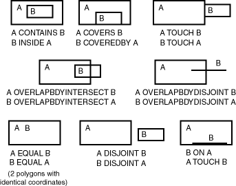
Strict containment versus boundary-inclusive containment
Let be a park polygon and a fountain footprint.
- If every point of , including its boundary, lies in the interior of , then contains .
- If reaches the boundary of , the relevant relation may be covers, not strict containment.
- If shares only part of its boundary with and their interiors do not overlap, they touch.
- If their interiors overlap, they overlap or otherwise intersect.
The relation is not a property of one object in isolation. It is a claim about a pair of geometries under a specified boundary model.
Boundaries are sometimes natural, sometimes stipulated
A cliff edge may seem like a natural boundary because there is an observable physical discontinuity. A national border is different: it is a legally and socially stipulated boundary, even if it is carefully surveyed and mapped. Both can be operationally real, but they are established differently.
The same distinction appears beyond geography:
| Object or region | Typical boundary basis |
|---|---|
| A lake | Water level, shoreline convention, measurement date |
| A nation | Legal treaty, statute, survey, and administrative authority |
| A university campus | Ownership, administrative definition, or built environment |
| A cloud | Chosen threshold for density, moisture, or visibility |
| A document section | Markup structure, heading hierarchy, or editorial convention |
| A search term | Tokenization, normalization, language rules, and index policy |
A cloud is particularly revealing. It occupies physical space, but its edge is usually not sharp. A satellite-imaging system may impose a threshold such as “pixels whose cloud probability exceeds a specified value.” This creates an actionable boundary, but the boundary partly reflects a classification rule and measurement resolution.
Boundary (Stanford Encyclopedia of Philosophy/Fall 2015 Edition)
Read the selected sections of the Stanford Encyclopedia of Philosophy entry “Boundary.” The aim is not to settle its philosophical disputes, but to recognize why boundaries cannot always be treated as obvious geometric facts.
In Section 1, “Issues,” begin with the extension of boundary talk beyond material objects. In Section 1.2, “Natural vs. Artificial Boundaries,” focus on the bona fide and fiat distinction. Then read Section 1.3, “Sharp vs. Vague Boundaries,” beginning at the problem of vague boundaries. Relate each case to a design question: must your locating system represent a crisp line, an uncertain zone, or a conventionally defined membership rule?
Boundaries can have uncertainty
A boundary on a map is not automatically a boundary in the world at arbitrary precision. Its apparent exactness can conceal:
- measurement uncertainty, such as an imprecise shoreline survey;
- scale dependence, where a coastline has more detail at one scale than another;
- classification uncertainty, such as deciding which cells count as urban;
- temporal change, such as a river channel moving;
- legal or institutional conflict, such as a disputed jurisdiction.
A responsible location claim can therefore include uncertainty rather than pretending that every object belongs unambiguously inside or outside a region.
For example:
At the dataset’s 10 m raster resolution, the point is classified as within the forest region.
This is much more informative than:
The point is in the forest.
The first claim identifies a dataset, a representation, a resolution, a classification boundary, and a relation.
3. Relations: what does “where” assert about two things?
A location claim often has the form:
where is a relation and and are identified objects or regions. In “the laboratory is in Building C,” the relevant relation may be:
But everyday language allows the word “in” to express several different relations:
- geometric containment: a point is in a polygon;
- structural containment: a file is in a directory;
- organizational membership: a researcher is in a department;
- topical membership: an article is in a subject category;
- temporal containment: an event is in an interval;
- textual occurrence: a phrase is in a document.
These relations are analogous because each situates one entity relative to another. They are not equivalent because they have different spaces, boundary rules, and retrieval procedures.
The properties of a relation matter
Before accepting a relational location claim, ask whether the relation is:
| Property | Meaning | Example |
|---|---|---|
| Directed | Reversing order changes its meaning | is inside differs from is inside |
| Symmetric | Reversing order preserves the relation | If touches , then touches |
| Transitive | Chained relations can establish a new relation | If a folder is in a directory and that directory is in a root tree, the folder is under that root |
| Metric-dependent | Requires a distance function and units | “Within 1 km” or “nearest hospital” |
| Topology-dependent | Depends on intersection and boundary rules | “Touches,” “contains,” and “disjoint” |
Do not assume transitivity. If café is near park , and park is near station , it does not follow that café is near station . “Near” requires a metric, a threshold, and sometimes a mode of travel. A geographically nearest clinic may not be the fastest clinic to reach on a road network.
Relation definitions are part of the reference system
“Adjacent” provides a good example. In a polygon database, two parcels may be adjacent if they share part of a boundary but have no overlapping interior. In a building-navigation system, two rooms might count as adjacent only if they share a door. In a graph, two nodes are adjacent if an edge connects them.
The same word is used, but the underlying relation differs:
| Space | Meaning of adjacency |
|---|---|
| Polygon map | Shared boundary segment |
| Raster grid | Shared edge, or sometimes shared corner, depending on connectivity rule |
| Room graph | Direct connection such as a door or corridor |
| Social network | Direct social tie |
| Document structure | Consecutive paragraphs or nodes under a common parent |
Thus, when a location claim uses a relation, the relation name alone is not enough. You need its operational definition.
4. Retrieval: how does a system turn a claim into access?
A location claim has practical force only if someone or something can use it. This is the role of the retrieval mechanism.
Retrieval may mean:
- navigating physically to a coordinate or address;
- resolving a filesystem path component by component;
- looking up an identifier in a registry;
- querying a database index;
- traversing a graph;
- searching an inverted index for documents containing a term.
The mechanism need not prove that the location claim is true. It provides a way to find, inspect, or test the relevant entity.
A spatial claim as a database query
Suppose a municipality asks:
Which buildings lie within the flood zone?
This question presupposes:
- Building identities, perhaps building-record identifiers.
- Building boundaries, represented as points or footprint polygons.
- Flood-zone identity and boundary, supplied by a particular authoritative dataset and edition.
- A relation, such as inside, covered-by, or intersects.
- A retrieval method, such as a spatial join or spatial index.
The query may return different results depending on whether buildings are modeled by roof centroids, entrances, full footprints, or parcels. It may also change when a flood-zone boundary is revised. The retrieval mechanism is therefore inseparable from modeling decisions.
Retrieving text is also locating
Now consider:
“Find documents that contain both fish and wall.”
This is a location task in an information space. The object is a document, the space is an indexed collection, and the relation is term occurrence under specific language-processing rules.
Inverted Index - The Data Structure Behind Search Engines
Watch “Inverted Index - The Data Structure Behind Search Engines” by Arpit Bhayani. It provides a compact computational example of how a system identifies documents, defines textual boundaries, records positions, and retrieves results from a query.
Watch the core index for the mapping from a term to document identifiers. Continue with term normalization; notice that tokenization, lowercasing, stemming, and stop-word policy define what the indexed “term” is. Then watch postings and offsets to see how positions within a document support phrase proximity and highlighting. Finish with Boolean retrieval, where posting lists are intersected to retrieve documents matching multiple terms.
An inverted index can be represented conceptually as:
For a term such as “fish,” a posting may store more than a document ID:
| Stored information | Locational role |
|---|---|
| Document ID | Identifies the document |
| Term frequency | Describes repetition within the document |
| Token position | Locates the term in the token sequence |
| Character or byte offset | Locates the exact textual span |
| Field or section | Locates the term structurally, such as in a title or body |
This is a valuable general lesson: retrieval systems build their own location spaces. A search engine does not search raw text character by character each time. It constructs an index that makes certain objects findable under a defined vocabulary and set of matching rules.
The index also reveals that boundaries are not exclusively physical. A token boundary determines whether "fish," is treated as the term fish; a document boundary determines which text belongs to which document; an offset boundary supports highlighting the exact span that matched.
A four-part audit for any location claim
When you encounter a statement of the form “ is ,” conduct this audit.
1. Identity audit
- What exactly is ?
- What exactly is ?
- Are names, identifiers, versions, and times specified?
- Is the level of granularity appropriate?
2. Boundary audit
- Is each object modeled as a point, line, region, interval, token sequence, node, or category?
- What is included in its boundary?
- Is the boundary crisp, uncertain, fuzzy, or stipulated?
- Does the representation’s resolution affect the result?
3. Relation audit
- What does mean operationally?
- Is it geometric, structural, hierarchical, temporal, semantic, or relational?
- Is it symmetric, directed, metric-dependent, or topology-dependent?
- Does the relation include the boundary or exclude it?
4. Retrieval audit
- What record, index, map, registry, path, query, or navigation procedure resolves the claim?
- Can an independent user reproduce the result?
- What reference data, software conventions, or access rights are required?
- Does the mechanism return the object itself, a representation of it, or merely a candidate match?
Here is the framework applied to one compact claim:
“Parcel P-104 is within 50 m of River R.”
| Audit component | Questions that must be answered |
|---|---|
| Identity | Which parcel registry defines P-104? Which river dataset defines R? At what date? |
| Boundary | Is the parcel a legal polygon? Is the river modeled as a centerline, bank polygon, or water surface? |
| Relation | Does “within 50 m” use shortest Euclidean distance? Geodesic distance? A buffered river geometry? |
| Retrieval | Which spatial database or GIS layer evaluates the distance query, in which coordinate reference system and units? |
Without those specifications, the statement may be useful conversationally but is not yet reproducible technical information.
When the framework breaks or needs revision
The four-part audit does not make every location claim perfectly determinate. Instead, it exposes where indeterminacy lives.
A location framework may fail or require adaptation when:
- identity is contested: “Who counts as the author of this collaborative document?”
- boundaries are fuzzy: “Where does the desert begin?”
- objects change through time: “Is this renovated building the same building?”
- relations depend on purpose: “Which hospital is nearest?” by straight-line distance, driving time, cost, or emergency capacity?
- retrieval depends on authority: a legal boundary, a social-media account, and an archival record may all use different identity and access systems.
- multiple locations are simultaneously valid: a book may be on a shelf, in a library classification, at a URL, in a database row, in a citation network, and near other books in semantic-vector space.
This is not a defect in the idea of location. It shows that “where” is a family of questions. Every answer selects a space, a relation, and an access method suited to a purpose.
Key takeaways
A meaningful location claim assumes more than coordinates or an address:
- Identity specifies the entity being located, at an appropriate granularity, scope, and often time.
- Boundary specifies where an object or region begins and ends, including whether the boundary is natural, stipulated, crisp, or uncertain.
- Relation specifies what positional claim is actually made: inside, contains, touches, overlaps, near, under, member of, or occurs in.
- Retrieval mechanism specifies how a human or system can resolve, query, navigate to, or verify the entity.
The same pattern works across geographic polygons, filesystem paths, document offsets, and search indexes. What varies is the kind of space, the definition of boundary, the meaning of relation, and the mechanism that makes the claim operational.
Next, we will use this expanded framework to diagnose precisely why a bare coordinate such as is underdetermined: it lacks not only a reference frame and units, but often an identified object, a boundary model, and a procedure for resolving the claim.
Can't find a good explanation? Sign up and we'll make it for you
Sign up