
Hello. In the previous lesson, you practised building an Economics explanation by showing each link between a cause and an outcome. Geography mapwork needs the same discipline: identify the information given, apply the correct method, keep units consistent, and check that the final answer makes sense.
This is your first Geography skill in the course. Map scale is a foundation for later work with gradients, topographic maps, fieldwork, and unseen spatial-skills questions. By the end of this lesson, you should be able to measure a straight or curved distance on a map and convert it into an accurate real-world distance.
Scale: a map’s conversion rule
A map is a reduced representation of a real place. Its scale tells you the relationship between a distance on the map and the matching distance on the ground.
The most common scale in Year 11 and Year 12 mapwork is a ratio scale, such as:
- 1:25 000 means 1 unit on the map represents 25 000 of the same unit in reality.
- 1:50 000 means 1 unit on the map represents 50 000 of the same unit in reality.
The word “same” matters. If you measure in centimetres on the map, the first calculation is in centimetres on the ground:
You then convert the ground distance into a more useful unit, usually metres or kilometres.
Two scales worth committing to memory are:
| Ratio scale | Ground distance represented by 1 cm on the map |
|---|---|
| 1:25 000 | 250 m or 0.25 km |
| 1:50 000 | 500 m or 0.5 km |
So a 1:25 000 map shows more detail than a 1:50 000 map. Although this sounds backwards at first, the denominator is smaller, so every centimetre represents less real ground.
Y11-12 Geography: Scale and Distance on Maps
Watch Y11-12 Geography: Scale and Distance on Maps from Atomi for a visual introduction to ratio, verbal, and linear scales. It also clarifies the easily confused distinction between large- and small-scale maps.
Watch the scale definition to establish what a ratio means. Then watch scale types, focusing on the examples for 1:25 000 and 1:50 000 and on why a large-scale map contains greater detail.
Maps may also use a verbal scale, such as “1 cm represents 500 m,” or a linear scale bar, marked in metres or kilometres. A linear scale is especially useful because you can compare a measured length directly against it rather than doing a full ratio calculation.
Before calculating anything, read the question carefully:
- If it asks for distance “as the crow flies,” measure a straight line between the two points.
- If it asks for the length of a road, track, river, coastline, or walking route, follow the actual curved feature.
- If it gives a required unit, such as kilometres, make sure your final answer is in that unit.
Calculating a straight-line distance from a ratio scale
For a straight-line distance, place a ruler between the two points. Align the ruler’s zero mark precisely with the first point, then read the measurement at the second point in centimetres.
The calculation has three stages:
- Measure the map distance in centimetres.
- Multiply by the denominator of the scale.
- Convert from centimetres to the unit requested.
In symbols, where is the map measurement in centimetres and is the scale denominator:
To convert centimetres to kilometres, divide by 100 000:
Worked example
A straight-line distance between two locations measures cm on a map with a scale of 1:25 000. Calculate the real-world distance in kilometres.
First, apply the scale:
Then convert centimetres to kilometres:
Therefore, the real-world distance is 1.85 km.
You can also use the quick fact that at 1:25 000, each centimetre represents km:
Both methods are valid. The full method is safer when you encounter an unfamiliar scale; the shortcut is useful when working quickly.
A reasonableness check
Before finalising an answer, estimate it. On a 1:25 000 map, 1 cm equals only 0.25 km. Therefore, a map measurement just over 7 cm should be a little under 2 km. An answer such as 18.5 km would immediately signal a unit-conversion error.
Y11-12 Geography: Scale and Distance on Maps
Continue with Atomi’s Y11-12 Geography: Scale and Distance on Maps for the full measuring-and-converting method, including a curved-route technique.
Watch ratio calculations for a worked straight-line example. Then watch linear and curved measures, paying close attention to keeping the zero point fixed while using a ruler, paper strip, or string.
Using a linear scale bar
A linear scale bar might look like this:
| Map length | Ground distance |
|---|---|
| A marked segment | 0 km to 1 km |
To use it:
- Measure the map distance with a ruler, strip of paper, or the edge of a spare sheet.
- Move that measurement down to the scale bar.
- Place the starting point exactly at 0, not at the left edge of a divided section unless that point is labelled zero.
- Read the matching ground distance.
This method avoids some arithmetic, but it still requires accuracy. If you begin at the wrong point on the scale bar, every later reading will be wrong.
A useful practical approach is to mark the two endpoints of your measured distance on a narrow strip of paper. This is often easier than trying to keep a ruler steady on a detailed topographic map.
Measuring curved routes
A ruler works well for a direct distance, but it will underestimate a road, river, or track that bends. For a curved route, use either a paper-strip method or string.
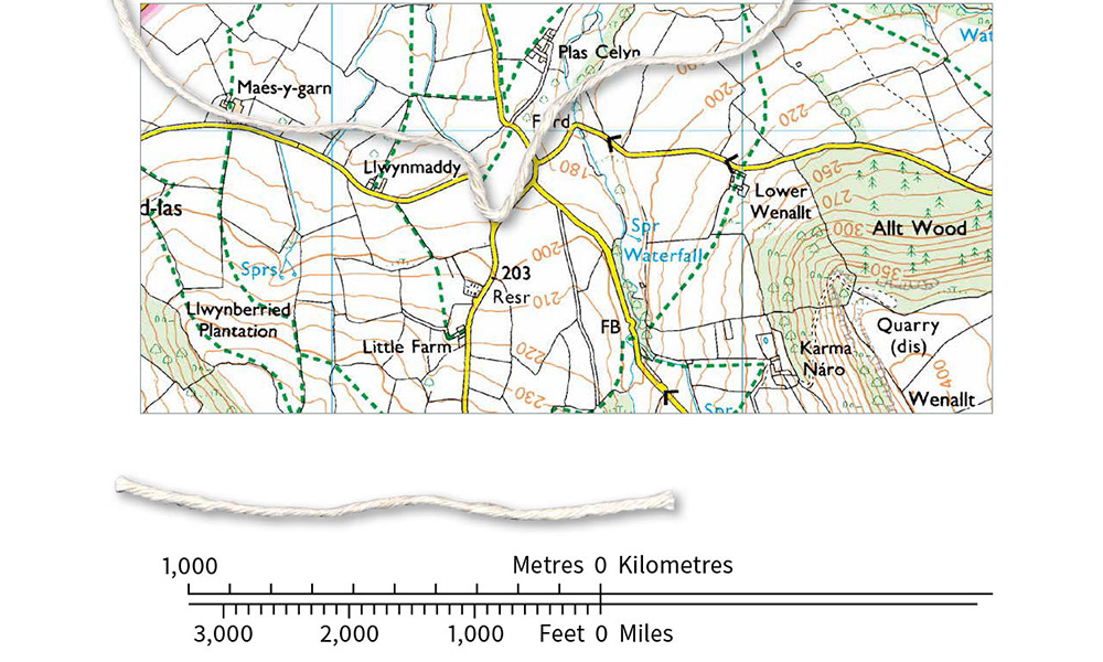
With the string method, gently lay a piece of string along the centre of the road, river, or route. Pin the start in place with a finger, bend the string around each curve, and mark or hold the end point. Then straighten the string and measure it against the map’s linear scale or with a ruler.
The image shows an important idea: the string first records the route’s map length and is then straightened only for measurement. You are not replacing the curved route with a straight-line shortcut.
If string is unavailable, use a strip of paper:
- Place one corner at the route’s starting point.
- Align the straight edge with the first short section of the route.
- Make a small mark where the route changes direction.
- Rotate the paper and repeat along the next short section.
- Continue until the endpoint, then compare the accumulated marks with the linear scale.
The more sharply the route bends, the shorter your individual sections should be. This reduces underestimation.
Read the NSW Department of Education transcript for two clear manual methods: measuring a straight distance with a ruler and measuring a curved route with either paper or string.
In the section describing the straight-line measurement, begin with the ruler method. Notice that the ruler measurement is transferred directly to the linear scale. Then, in the curved-route section, read the paper-strip method, followed by the explanation of measuring with string. Focus on why the route must be followed in small sections rather than measured with one straight line.
A complete mapwork response
In an exam, show enough working for the marker to see your method. A clear response might look like this:
Distance on map cm
ScaleGround distance:
Therefore, the road distance is 3.4 km.
At a scale of 1:50 000, 1 cm represents 0.5 km, so a fast check is:
The wording matters. If the question asks for a road distance, write “the road distance is 3.4 km,” not simply “the distance is 3.4.” Include the unit every time.
Common errors and how to prevent them
| Error | Why it happens | Prevention |
|---|---|---|
| Treating 1:25 000 as 1 cm equals 25 000 km | The unit is ignored | Remember that both sides use the same unit first: cm maps to cm. |
| Forgetting to convert centimetres | The calculation stops too early | Check the unit requested, then convert at the end. |
| Measuring a curved road with one ruler line | This measures direct distance, not route distance | Use string or several short straight sections. |
| Starting from the wrong point on a ruler or scale bar | The initial zero is not aligned | Put the zero point exactly on the first location or scale-bar zero. |
| Rounding too early | Small inaccuracies build up | Keep the full measurement until the final step. |
| Giving no unit | The answer is incomplete | Write m or km after every final distance. |
Add errors you make in this skill to your cross-subject error log. For example:
| Mistake | Error type | Repair |
|---|---|---|
| Divided by 25 000 instead of multiplying | Reasoning or execution | Write what 1 cm represents before calculating. |
| Answered a curved-road question with a straight-line measurement | Question interpretation | Underline the feature named in the question. |
| Reported 125 000 cm when kilometres were requested | Execution | Circle the required final unit before beginning. |
Key takeaways
Map scale converts a map measurement into a real-world distance.
Remember the core method:
- Identify the scale and the type of distance required.
- Measure accurately, using a ruler for straight distances and string or paper for curved routes.
- Multiply the map measurement by the ratio-scale denominator.
- Convert into the requested unit.
- Check that your answer is plausible and include units.
For the common scales:
- At 1:25 000, 1 cm represents 0.25 km.
- At 1:50 000, 1 cm represents 0.5 km.
Next, you will switch to English Advanced and practise annotating an unseen passage for textual evidence, technique, and effect. The subject changes, but the underlying exam habit remains: identify precisely what is in front of you, then make each step of your reasoning visible.
Can't find a good explanation? Sign up and we'll make it for you
Sign up